
Getting to the island.
Access to Sipson Island currently is by private boat only. Commercial boats are not permitted to land.
As the map below shows, there are a dozen or more public town landings and beaches where you can launch a kayak, paddleboard, or powerboat. Only designated landings have boat ramps. Parking is limited at all locations — some have just a few spots. Please park legally and observe all posted signs. Parking is controlled by sticker at Chatham landings (except Jackknife Cove).
You can find more details in the Town of Orleans Coastal Access Guide and the Pleasant Bay Map & Resource Guide. Find state boating information here. If you still have questions after reading this page and our FAQs, contact us.
Please note! Much of the Pleasant Bay shoreline is privately owned. Roads discovered on GPS may be private: do not use roads signed as private to access the shoreline around Sipson Island. Thank you for respecting our neighbors!

Members of the public can access the shoreline at numbered sites for travel to Sipson Island. Limited parking varies from 1 to 20 spots. Locations with ramps for trailered boats are marked with * Use GPS maps for street navigation. Do not use private roads discovered on GPS to access shorelines. For landing zones on the island, see detailed island map.

Paddlers
Kayaks can be launched from any of the sites on the map, but note distances from the closest locations and plan accordingly. For example, on a calm day it takes about 45 minutes for a skilled kayaker to paddle from Sipson Island to Jackknife Cove (sometimes called Head of Pleasant Bay). However, conditions in Pleasant Bay can be challenging, with strong tidal currents and wind. A southwest wind (typical in summer) will add significantly to your time and effort. We don’t recommend the bay for first-time paddlers. Always check weather and wind forecasts before embarking. Bring plenty of water, flotation device, and a phone for emergencies; try not to kayak alone. (Life jackets required from May 15 – Sept. 15 by state law.)
Kayak and paddleboard rentals are available, if you have a way to transport them to a public launching point. Some outfitters deliver. Always check with the outfitter for most current information.

Powerboaters
Landings with launch ramps are shown with asterisks (*) on the map. Please be respectful of fellow boaters, stay in marked channels, and observe rights of way. Harbormasters enforce compliance with No-Wake zones, such as The Narrows. Please proceed slowly anywhere close to the shores of Sipson Island.
Hazards Rocks and shoals are present in many places around the island. Hazardous rocks off the north end are marked by a white buoy; keep to the northeast of that buoy. Be sure to calculate tides before going out: much of Pleasant Bay is shallow and tides may not follow a typical 6-hour cycle. Except at very high tide, do not attempt to cross the south end of Sipson Island, where a spit forms.
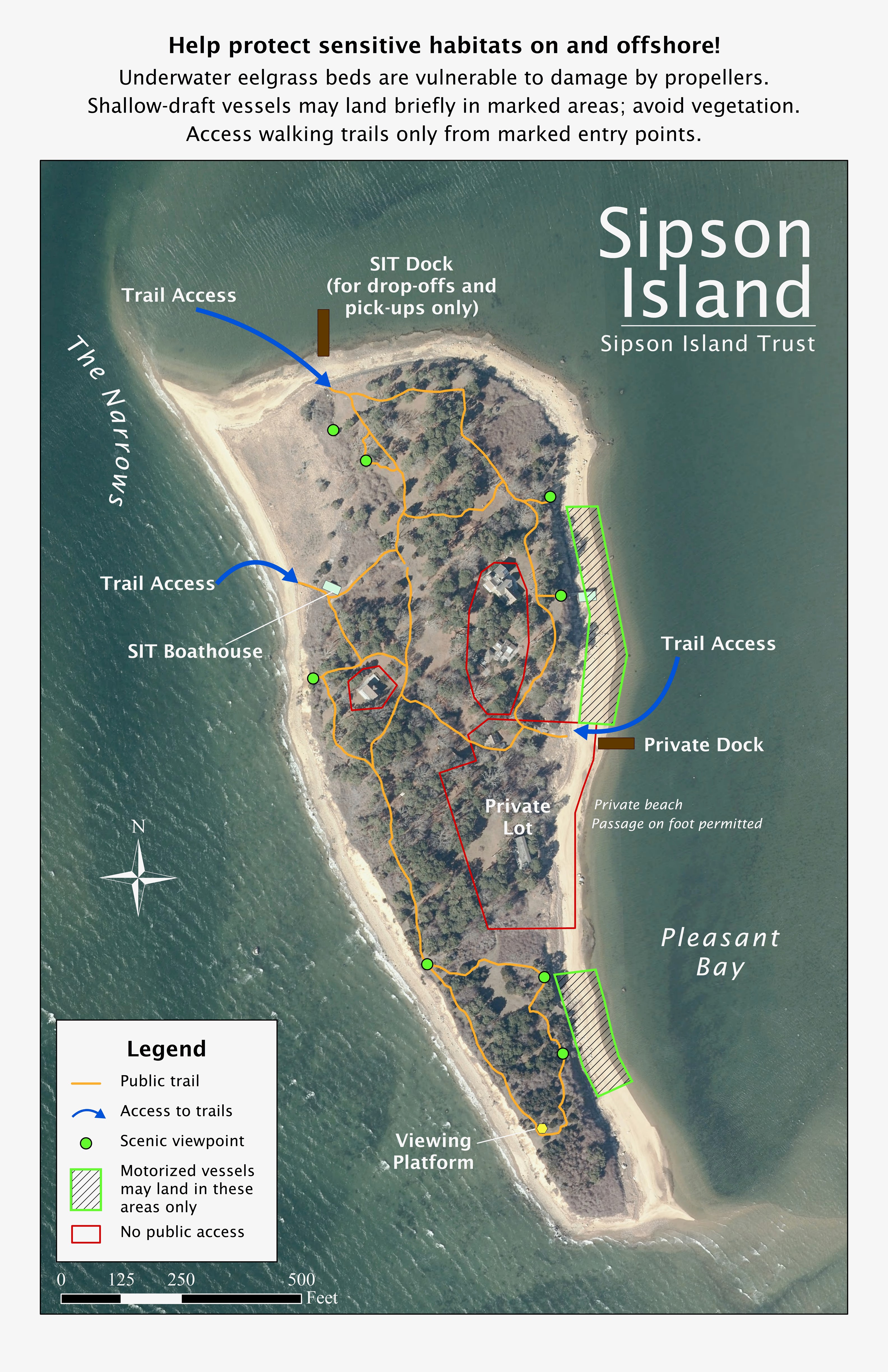
Landing Because the island is surrounded by critical marine habitat, only shallow-draft boats (under 22 feet) may land — and only on the eastern side. Other craft should anchor offshore, staying clear of vegetation as much as possible. Please avoid anchoring in or near The Narrows.

Practice safety and environmental awareness, on and off the water.
Always wear a life jacket when boating (paddlers must wear life jackets May 15–Sept. 15)
Keep away from seals
Keep off fragile ecosystems like salt marshes and eelgrass beds
Keep clear of areas restricted for nesting birds
Useful phone contacts.
U.S. Coast Guard Emergency 508-945-0164
Orleans Harbormaster 508-240-3755
Harwich Harbormaster 508-430-7532
Chatham Harbormaster 508-945-5185